GPS
![]()
![]()
|
GPS
|
|
|
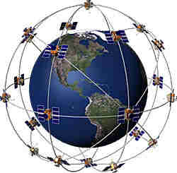
Global Positioning System, every one has heard of this these days, the receivers are so cheap now that people are using them for hiking and other leisure pursuits. The system comprises of 3 elements; the control element which are the US department of defence ground control stations. These monitor the satellite status, correct their data and occasionally correct the orbit of a satellite that has drifted too far from its set path the space element which consists of 27 polar orbiting satellites, these 27 satellites are distributed into 6 orbits each inclined at 60 degrees to the plane of the equator, this distribution is designed to ensure that at least 4 satellites are visible to a receiver from most places on the earth. The satellites orbit is set at 20,190 km above the earth.
GPS satellite orbit around the Earth the user element which is the receiver and antenna. each satellite consists of 3 extremely accurate clocks which are synchronised to a ground master clock, these clocks control the timing of the transmission from the satellite, the message transmitted contains the position of the satellite, the time of transmission and the health / operational condition of the satellite (there are other items of information as well but they are not relevant to position fixing) the user element is an electronics package that tracks and decodes the satellite signals, has a low accuracy (comparative to the caesium clocks in the satellite) clock and a processor for calculating its position. basically the satellite transmits a signal, the receiver receives it and by knowing the difference between transmission time and reception time the distance the signal has travelled can be calculated, this gives us a range from the satellite. The problem of the low accuracy clock in the receiver is resolved by observing several (4 or more) satellites signals which means the clock error can be calculated. With ranges from 4 satellites an accurate 3 D fix can be obtained (latitude, longitude and height) To determine velocity, some of the lower market receivers interpolate between successive position fixes, dividing distance between fixes by time between fixes to give speed. There is a more accurate way to measure this, called doppler shift. Doppler shift is the name given to the change in frequency of a wave (sound is a wave) due to the relative motion between the transmitter and the receiver. We know the speed of the satellite and can measure the doppler shift, which means we can accurately calculate our own speed. To hear an example of doppler shift, listen for the next ambulance siren, as it gets closer to you the pitch of the sound increases and then as it passes you the pitch decreases. This is due to doppler shift, i.e. the frequency changing due to relative velocities When GPS was first introduced, the coarse acquisition signal (L1) that was available for civilian use only gave an accuracy of around 100m, fine for general navigation but not for critical positioning. Commercial developers quickly developed systems that could provide accuracy levels similar to military equipment and the US department of defence introduced deliberate variable errors to the L1 signal that again caused the accuracy to be in the region of 100m. This variable error was known as selective availability (SA). To get around this, where accurate positioning was required, commercial companies came up with differential GPS (DGPS), basically this consists of a series of reference stations at accurately known positions, they compare calculated ranges from the satellites radio transmission to the actual range, calculate the errors and then transmit these to the vessels using the service. These corrections (RTCM) are combined by computer on the vessel together with the GPS position information and an accurate ( 3 to 5 m) position obtained.
Simplified DGPS illustration showing one satellite and one reference station, in reality a minimum of 4 satellites are required and it is normal to use several reference stations. Selective availability was turned off in May 2000 consequently the position accuracy is in the region of +/- 15m, but DGPS is still used in most position critical applications as it reduces the other non-deliberate errors to give a position accuracy in the region of +/- 5m and improves repeatability / consistancy |